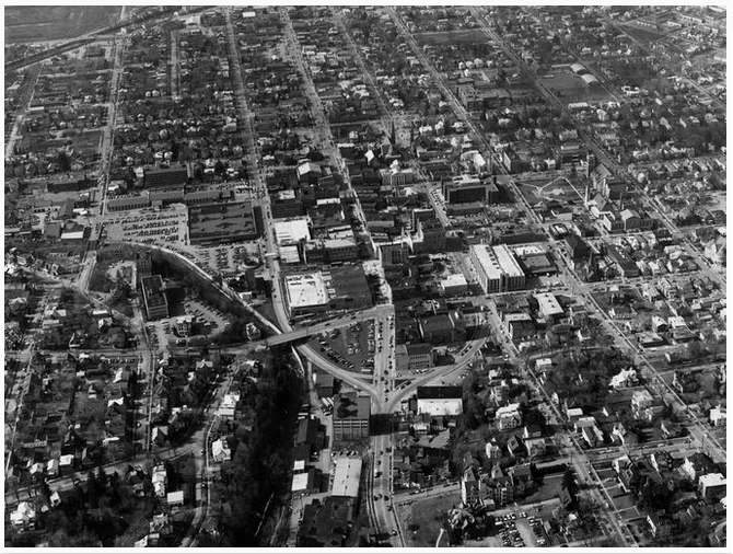
Photo from C. Hadley Smith Collection
For Part I, click *here*.
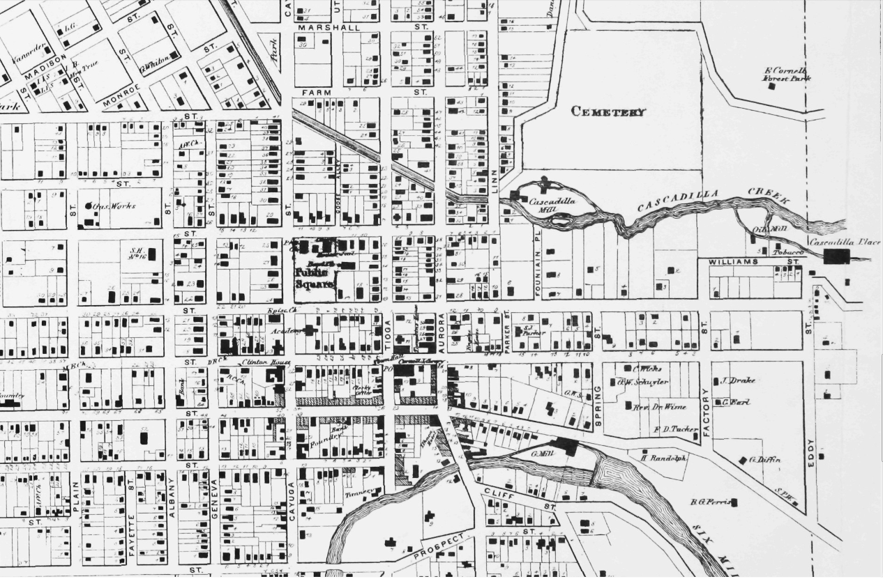
Once the federal funding for Project One came through in December 1964, the gears had started to turn. In Spring 1965, the president of the Hotel Ithaca bought the Clinton House for use as a temporary facility while the new hotel was built. Funds and plan details were formally accepted and approved by the Feds and Common Council in May 1965, and the Ithaca Urban Renewal Agency (IURA, which still exists today) was incorporated.
The IURA was long a sore spot among city councilmen because Democrats were opposed to it and Republicans were in favor of it. The city was a little less one-sided with its politics back then.
In 1966, two developers were designated for two properties in the Project One area. One would build a set of retail spaces, the other would be responsible for what would be the nation’s largest Woolworth’s department store.
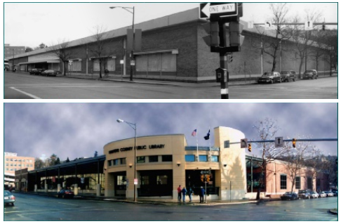
For those too young to know, Woolworth’s was a major discount and department store chain – a sort of Walmart or Target of its day (and more like a Kmart towards the end), which was from the 1880s to 1990s. The Woolworth’s was supposed to draw people into downtown, and would be on the corner of S. Cayuga and W. Green Streets.
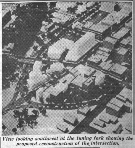
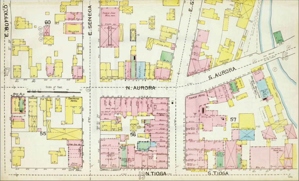
Problems arose when Woolworth’s said it would need even more parking space than planned. The city, fearing the department store would end up in the suburbs, rushed to condemn three properties on the edge of the project area, two car dealerships and a repair shop. The buildings were demolished, acres of parking laid, and the store opened in the winter of 1968/1969.

Image property of QPK Architecture
It was not an attractive building by a long-shot, but the store did draw people downtown, and it remained open until about 1998, when the entire chain went under. Today it’s the county library, and the entire block has once again been redeveloped, which was previously written about here.
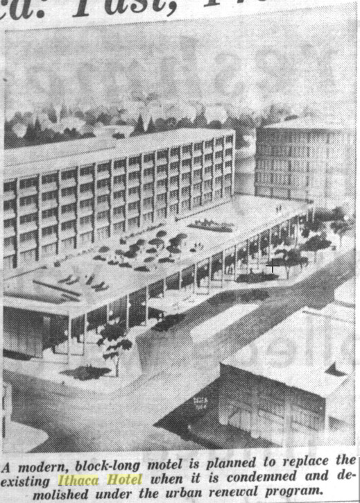
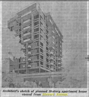
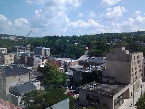
The closest Ithaca got to that chic modern hotel was the Ramada that opened in 1972 (later Holiday Inn, and now the Hotel Ithaca). That fell just outside the Project One boundary line. The original 1970s hotel, without the “Executive Tower” built in 1985, can be seen in the lead image.
The Hotel Ithaca fell to the wrecking ball in 1967, around the same time that the 2, 4 and 5-story buildings across the street from the Carey and CSMA also came tumbling down. Until the Marriott currently under construction, the city struggled to find a developer interested in the site; the site was developed in 1975 into the new Rothschild’s Building, but the older 1870s structure further up the Commons was demolished, the last of the federally-funded urban renewal demolitions.
After several years of attempting to find developers for the old Rothschild’s site, two local developers finally managed to cobble together enough funding to build Center Ithaca in 1981. Center Ithaca went bankrupt not long after opening, and Rothschild’s closed up in 1982, so the whole block over there has been pretty underwhelming ever since urban renewal touched it.
If anything, the south side of the tuning fork did worse; the potential bank tenant never followed through on its original intent, the city tried for years to sell the property. After several years they finally managed to get rid of the vacant lot. The Trebloc Building was originally planned to have two floors, but financial troubles reduced it to one. The abomination opened in 1974.
The Ithaca Commons, which also opened in fall 1974 and was completed the following spring, falls outside of the realm of Urban Renewal as discussed here because it was funded with local bonds, rather than federal monies. The idea of a Commons didn’t start to gain traction until about 1971, after most of the urban renewal projects had left their mark on downtown Ithaca.
Like much of downtown, the Commons struggled with high vacancy rates for years, and the mix of stores never quite met the city’s expectations – where the city leaders envisioned department stores and “everyday retail” such as drugstores, neither of those have been historically successful on the Commons, and the use of the Commons as an open-air drug market was an unexpected, unpleasant surprise. It’s really only been in the past 15 years that the Commons has enjoyed low vacancy and strong tenant interest.
See, Ithaca’s urban renewal never quite stopped the overall trend of movement to the suburbs. With each decade, development sprawled further and further out, and it still is in parts of Ithaca town and Lansing. For the Jon and Jane Q’s just looking to buy groceries or hit up a fast food place, downtown Ithaca wasn’t on the radar.
But there were folks who were still drawn to the charm of a built-up downtown, where emphasis was on two feet rather than four wheels. It was an eclectic bunch – older residents still heavily invested in downtown, and younger, poorer, counter-culture types settling in the area during 1960s and 1970s. Ithaca’s dilapidated downtown, where many retail chains feared to tread, is where a lot of the region’s unique “vibe” sprouted, albeit unintentionally.
And, as things go, what’s old is new. There’s a renewed interest in denser, walkable communities, whether for sustainability, cultural amenities, or simply to experience something different from the cul-de-sacs and strip malls that many Gen X’ers and Millenials grew up with. Ithaca, with a stable, growing economy and plenty of fresh blood flowing in and out of the community, was poised to capitalize on this, and his done so with a fair amount of success in recent years, attracting both national retailers and keeping most of its character intact. Had it not for the renewed interest in walkable downtowns, newer urban renewal projects such as Cayuga Green would likely have been as unsuccessful as Center Ithaca.
The car, once a defining aspect of America’s cultural scene, is now more likely to be treated as an appliance, like a washing machine or microwave. It does what one needs it to do, but the allure isn’t what it used to be. Parking lots used to be eye-catching splashes of color, coral and peach, turquoise and sea green; and now, beige, grey, and subdued reds and blues. The symbolism is there.

Urban renewal in the tear-down and pave everything sense was stopped for two reasons – money and opposition. But money was the much more important one.
In the later 1960s, funds for urban renewal started to dry up. The city dropped projects two and three and combined elements of the two for a second phase of downtown, and a proposal for Collegetown. The Collegetown proposal was submitted (much to the chagrin of Collegetown landlords), but much of it got lost due to competing interests in the bureaucratic quagmire, and never moved forward under its original intent. The end result was the parking garage, Schwartz Center for the Performing Arts, and the Eddygate mixed-use complex, all of which came to fruition much later in the mid and late 1980s.
Meanwhile, residents began to rise up in protest after seeing so many historic buildings demolished in favor of projects that were never built, or were downright ugly. Although too late to save buildings like the Hotel Ithaca and the old City Hall, groups like Historic Ithaca were important in keeping buildings such as the Clinton House and DeWitt Mall from meeting the same fate.
It would be unfair to cast those who supported urban renewal as malignant or devious. No city official, no mayor, no one with a vested interest in downtown Ithaca set out to wreck it. They were trying to revitalize it, and they were listening and applying the auto-centric, “old equals bad” thinking that had been popular in the years leading up to renewal. The results left a lot of hard feelings, and a lot of unmet hopes.
Yet, the issues that faced downtown Ithaca fifty years ago, the problems that the city’s political and business leaders were never quite able to solve, eventually became assets. Old buildings, now loved for character. Walkable streets, now appreciated. Mixed retail, offices and housing, contrary to single-use zoning, now embraced. Ithaca’s old bones, once a persistent ache, have assisted Ithaca in becoming the vibrant city that it is.
Buildings and streets can be planned. But the people occupying them? Maybe not so much.
Not everything can be planned. And that’s a good thing.