I have to be honest, up to last night, I had no freaking clue what a woonerf was. It sounds like a children’s made-up word (ex. thingamigjig or doohickey; my brother used “pedewa”). But apparently, it’s a legit urban planning concept. Woonerf is Dutch for “living yard”, and is a type of “living street” where equal priority is given to cars, bicyclists, and pedestrians (the speed limit is no more than about 10-12 mph). They’ve seen substantial implementation in Western Europe since their introduction in the 1970s. The more I read about them, the more I get the impression that it’s a curious blend of a thoroughfare and a courtyard, or Ithaca Commons with vehicle traffic.

Image Courtesy of localmile.org
I’m not inclined to look up new words without a purpose, and the reason this time around comes courtesy of the planning board of the town of Ithaca, with the following project up for review at the meeting on May 20th:
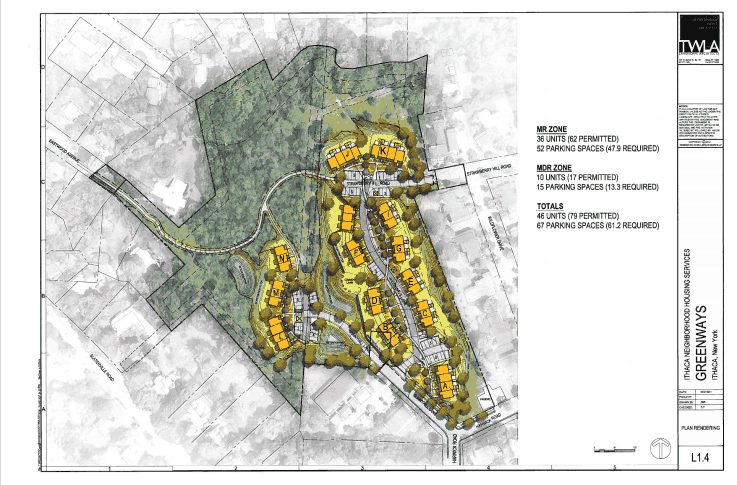
Consideration of a sketch plan for the proposed Greenways project located off Sunnyhill Lane and Strawberry Hill Road, Town of Ithaca, Tax Parcel No.’s 60-1-34.2 and 60.1-1-46.22, Medium Density Residential (MDR) and Multiple Residence Zones (MR). The proposal involves the development of 46 townhouse units west of Eastwood Commons, fronting woonerf-style roads that will connect Sunnyhill Lane and Strawberry Hill Road.The project will also include new parking areas, open space, recreation areas, trails, walkways, landscaping, outdoor lighting, and stormwater facilities. Cornell University, Owner; Ithaca Neighborhood Housing Services, Applicant; Peter Trowbridge, Trowbridge Wolf Michaels Landscape Architects, Agent.
Regular readers will recognize the name Greenways because I’ve latched onto this project and followed it with interest since first proposed about 18 months ago (one could argue I’ve beaten a dead horse here). The project was originally proposed with 67 units, but then dropped to 46 by the time updated specs were submitted in February. The site is still the same, seeking to use woonerfs to connect Sunnyhill Drive and Strawberry Hill Circle. Note that google is not correct here, the street labels are all botched up. An accurate map with the parcels outlined (copied from the county tax map) is included in the lede for this post. Given a preferred completion in October 2015, and that this project consists of 46 units of townhouse-style housing, it makes sense that it would be seeking planning board approvals now.
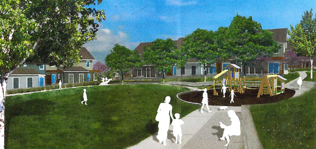
Image property of Greenways at Eastwood Commons
So make way for the woonerfs, I suppose.
EDIT 5/15: Now we have renders and site plans. It looks like the project will be built in three phases, and access to “Greenways Lane” will be primarily through Strawberry Hill Toad and Sunnyhill Lane. The “woonerfs” seem rather gimmicky in this context.